
Landfill Underground Fire Detection
Find It While It Is Still a Hot Spot
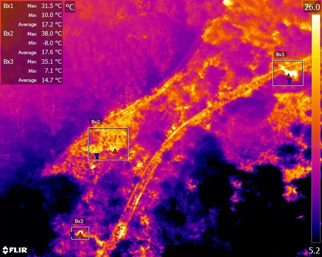
Aerial thermal survey of active and closed landfill to locate the surface expression of subsurface heating, before a smouldering mass becomes a notifiable fire. Covers a whole cell or an entire site in a single flight, mapped and georeferenced, so hot spots can be found, ranked and then watched over time. Analysed and reported by an ITC Level III Certified Master Thermographer.
Find It While It Is Still a Hot Spot
A subsurface landfill fire does not announce itself. Buried waste oxidises, the oxidation gives off heat, and because the surrounding mass insulates it the heat has nowhere to go. Given air it accelerates, and it can run for months underground before anything is visible from the surface. By the time there is smoke, steam or subsidence, the problem is well established, expensive, and a conversation with the regulator.
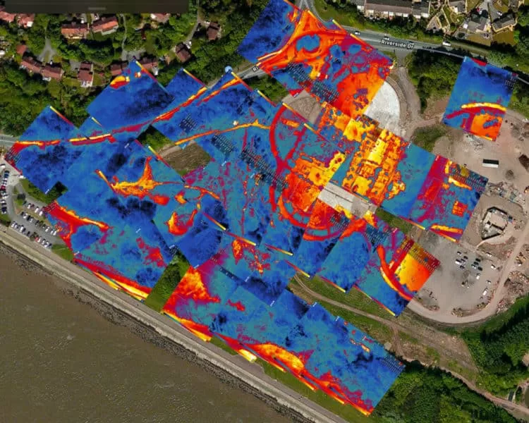
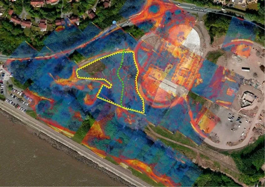
Thermal survey from the air looks for it earlier, at the stage where it is still a warm patch on a cap rather than an incident. A whole cell is covered in one flight, at night, and what comes back is a georeferenced map of every thermal anomaly on the surface, ranked, so that the ones worth investigating on the ground can be found again by somebody standing on the site with a probe.
What the Survey Looks For
Surface heat, and the shapes that distinguish it from everything else
Nothing airborne sees underground. What the camera reads is the surface of the cap, and what makes the technique work is that heat generated below eventually reaches that surface and changes its temperature in a way that has a recognisable shape.
The signal is usually diffuse rather than sharp. Heat conducting up through metres of waste and cover spreads out on the way, so a subsurface source typically presents as a soft-edged warm region rather than a hard outline. That is a useful diagnostic in itself, because most of the things that produce a crisp thermal edge on a landfill are surface features: a track, a plant base, exposed geomembrane, a pool of standing water, freshly tipped material.
Gas infrastructure is read alongside it. Wells, headers and flares carry their own heat and can either mask a nearby anomaly or be mistaken for one. Knowing where the infrastructure runs is part of the interpretation rather than an afterthought, which is why the site plan is asked for before the flight rather than after the report.
Freshly placed waste is warm anyway. Biological activity in recent material produces a genuine and entirely normal temperature rise, and reporting that as a fire risk is the fastest way to lose a client’s confidence. Distinguishing normal decomposition warmth from something accelerating is a matter of the pattern, the setting, the age of the material and, above everything, how it has behaved since the last survey.
Each anomaly is located, given a coordinate, described, and graded, so a site team can walk to it and put a probe in the right place.
At a glance
What an aerial thermal survey can and cannot tell you about a fire underneath a landfill.
- Covers a whole cell or site in one flight, at a consistent height and in one set of conditions, which a walkover with a handheld camera cannot do across that area.
- Detects the surface expression of subsurface heat, mapped and georeferenced so each anomaly can be relocated on the ground and probed.
- Ranked, not just listed. Anomalies are graded by how strong the signal is and by whether the shape and setting support a subsurface cause rather than a surface one.
- Repeat surveys are where the value is. One flight is a snapshot; the same flight again in a month shows whether a hot spot is growing, migrating or dying, which is the question that actually drives intervention.
- Shallow heating reads far better than deep heating. A deep-seated mass may show only diffuse surface warming or nothing at all, and the survey says so rather than reporting a clean bill of health.
- Conditions decide detection. Surveys are flown at night, and stood down for wind, rain and recent solar loading, because those will hide a hot spot that is genuinely there.
The survey narrows a whole site to a handful of places worth digging. It does not replace the digging.
Related Thermal Work
One Survey Is a Snapshot, Two Are a Trend
Growing, migrating or dying, and why that is the real question
A single thermal survey tells you that a warm area exists. It does not tell you whether that area is a problem, and on a landfill that distinction is almost the whole decision, because a site will always have warm patches and only some of them matter.
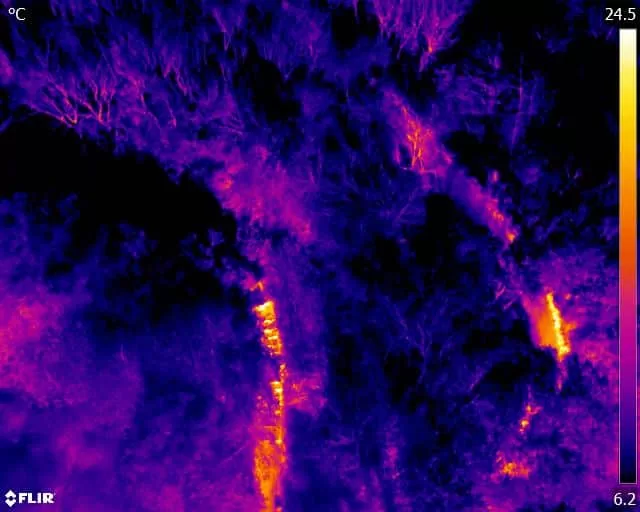
What changes the picture is the second survey. Flown to the same specification, over the same ground, at the same height, in comparable conditions, the two can be subtracted from one another. An anomaly that has grown, intensified or moved is behaving like combustion. One that has faded is behaving like ordinary decomposition or a surface effect that happened to be there on the night. That distinction cannot be drawn from one flight by anybody, however experienced.
Comparability has to be designed in at the first visit, not attempted at the second. Height, camera settings, flight pattern, season, time relative to sunset and the radiometric parameters all shift what the surface reads, and if any of them drift between visits the difference measured is partly the survey rather than the site. Fixing the specification at the outset is unglamorous and it is what makes the comparison defensible later.
For a site under a management plan or regulatory attention, that record is the deliverable. A dated sequence of surveys showing a hot spot located, monitored and either intervened upon or observed to decay is a far stronger position than a single alarming photograph, whether the reader is a regulator, an insurer or a board being asked for money.
Where a site is already known to have a problem, the same approach tracks whether the intervention is working, which is a question that is otherwise answered by opinion and by how much steam is visible on the day.
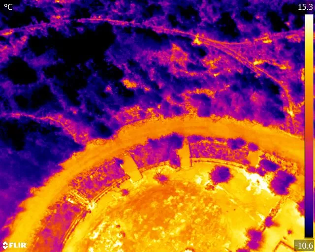
Aerial Thermal Survey of an Underground Fire on a Former Landfill
A radiometric thermal survey flown over a closed landfill site to investigate suspected underground burning. The flight covered ground that could not be assessed on foot in any reasonable time, and located the surface thermal signatures associated with subsurface heating, mapped so that each could be found again and investigated properly from the ground.
Why a Clear Survey Is Not a Clean Bill of Health
The most important sentence in a landfill thermal report is frequently the one about what the survey could not have seen, and it is the sentence most likely to be left out.
Depth is the fundamental limit. Heat from a shallow source, in relatively recent material, reaches the surface strongly and reads well. Heat from a deep-seated mass under many metres of waste and cover may produce only faint, broad surface warming, or nothing measurable at all. A deep event is exactly the one you most want to know about, and it is the one the technique struggles with most. Any survey that reports a site clear without saying that is overstating itself.
Conditions can hide a real hot spot entirely. Wind moving across the cap carries away the surface layer the camera is reading. Rain wets the surface and levels everything out. A day of strong sun leaves a warm cap that swamps a subtle anomaly for hours. This is not theoretical: waste operators have been disappointed by thermal surveys that missed hot spots already known to be present, and the cause is usually the conditions the survey was flown in rather than the technology. It is the reason a survey will be postponed rather than flown on a marginal night, and the reason the conditions are recorded in the report so the result can be weighed properly.
The survey does not confirm combustion. It reports temperature at the surface. Whether the cause underneath is oxidation, biological activity, a gas well running warm or something else entirely is established on the ground, by probing, by gas monitoring and by temperature measurement at depth. The survey exists to tell you where to do that work, which on a site of any size is the difficult part.
What it does exceptionally well is coverage and repeatability. An entire cell, seen in one night, under one set of conditions, mapped to coordinates you can return to, and repeatable to the same specification for as long as the site needs watching. No walkover achieves that, and the walkover is what it is usually being compared with.
Subsurface landfill fires are usually described in two broad families, and the difference matters because it changes both what causes them and how well a thermal survey will find them.
Shallow events sit relatively close to the surface, in comparatively recent material, and commonly begin with an ignition source rather than with the waste itself: hot material tipped into the cell, a spark from plant, or something introduced with the load. They tend to produce a stronger, better defined surface signature simply because there is less material between the heat and the camera. These are the ones aerial thermography is genuinely good at finding early.
Deep events sit under significant depth, generally in older waste, and are more often self-heating: oxidation of organic material releasing heat faster than the surrounding mass can carry it away. Because oxidation is exothermic, once it establishes it can sustain itself, and because it is insulated by everything above it, it can persist for a long time. What reaches the cap is attenuated and spread out, so the surface signature is weaker, broader and easier to miss.
Air is what governs both. Combustion needs oxygen, and in a capped mass oxygen is the limiting factor. This is why disturbance frequently precedes an incident: excavation, settlement cracking, a failing cap, gas extraction drawing air in, or works that open a path. A survey read alongside where the site has recently been worked is more useful than one read on its own.
The practical consequence for the survey is that a strong, well-defined anomaly usually means something shallow and recent, and a faint, broad, persistent one may mean something deeper and considerably more serious. Signal strength is not the same as severity, and reading it that way inverts the risk.
- Thermographic inspection, analysis and reporting are conducted by Steve Fisher, ITC Level III Certified Master Thermographer (Infrared Training Centre; Certification #205722059), practising in accordance with the frameworks of ISO 18436-7:2014, ASNT SNT-TC-1A and ANSI/ASNT CP-105, and BINDT CMGEN Appendix B (UK training governance).
- Thermography detects surface temperature, not subsurface combustion. Findings are reported as located thermal anomalies with a graded likelihood of a subsurface cause, never as confirmed fire, and confirmation remains a ground-based investigation.
- The conditions at the time of survey are recorded and reported, because wind, precipitation and recent solar loading all reduce detection. A survey flown in unsuitable conditions is postponed rather than qualified after the event.
- Where repeat monitoring is undertaken, the flight specification, height, pattern and radiometric parameters fixed at the first survey are reproduced at each subsequent visit, so that change between surveys is attributable to the site.
- Flight operations are conducted under a Civil Aviation Authority Operational Authorisation held against the PDRA-01 standard scenario, with a General VLOS Certificate (GVC) and an A2 Certificate of Competency, and are planned around the site operator’s own permit conditions and safety rules.
- Drone Media Imaging provides survey, analysis and reporting. Intrusive investigation, gas monitoring, excavation, firefighting and remediation are not offered and remain with the site operator and the appropriate specialists.
Tell Us the Site, the Cell and What You Suspect
Send us the location, the area to be covered, and what has prompted the enquiry, whether that is visible steam, a smell, a gas reading, settlement, a regulator asking questions or simply a wish to establish a baseline before anything happens. A site plan showing gas infrastructure and recent working helps considerably, because both change how the results are read. You will get a fixed price back, the conditions the survey needs, and a straight answer about what a survey of this site will and will not be able to tell you. If you are likely to want repeat monitoring, say so now, because the specification is worth fixing at the first flight rather than the second.



