
Fire Monitoring
Knowing Whether It Is Actually Out
Repeat thermal observation of a site that is burning, smouldering or recently extinguished, flown from outside the exclusion zone and reported as calibrated measurements rather than impressions. Used where a mass cannot be approached or opened, and where the decision to re-enter, demolish or stand down needs evidence. Conducted by an ITC Level III Certified Master Thermographer, in support of the responsible authority.
Knowing Whether It Is Actually Out
A fire in a bulk material is rarely over when it stops looking like a fire. Grain, waste, timber, wood chip, baled recyclate and stored product all insulate themselves, so combustion continues deep inside a mass long after the visible flame has gone. Water goes onto the outside and the middle keeps burning. What everybody needs to know, and nobody can see, is what the temperature inside is doing over the following days and weeks.
Thermal observation from the air answers that repeatedly, safely and from a distance. Flights are made from outside the exclusion zone, to a fixed pattern, producing calibrated measurements of the same points every time. What that gives an incident team is a trend rather than a snapshot, which is the difference between believing a site is cooling and being able to demonstrate it.
What the Monitoring Delivers
A measured trend the incident team can act on
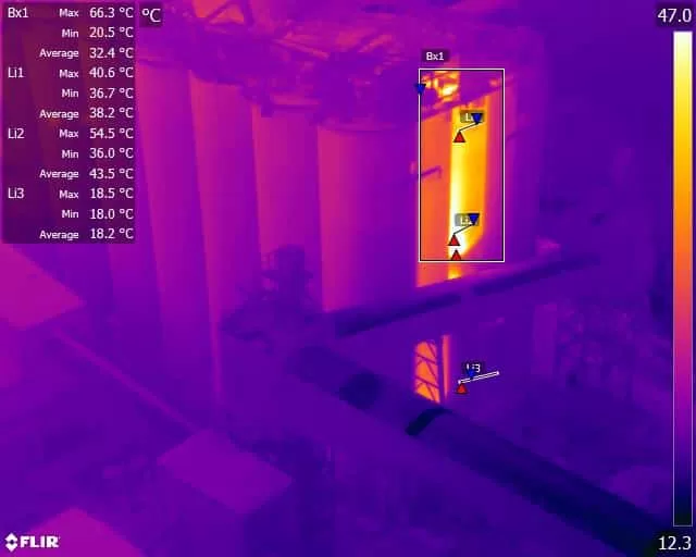
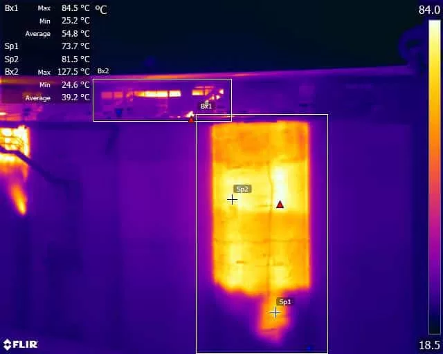
The output is a repeating set of measurements rather than a report at the end. Each flight covers the same points, from the same positions, with the same camera parameters, so the numbers can be placed alongside the previous ones and read as a curve.
Peak temperatures and where they are. The hottest points on the site, located and measured, showing whether the seat of the fire is where everybody assumes it is and whether it is moving through the mass.
The direction of travel. Whether temperatures are falling, holding or climbing is the question that decides everything else, and it can only be answered by comparison. A single reading of 300 degrees means very little; the same point at 300 last Tuesday and 180 today means the intervention is working.
New hot spots. Fires in bulk material move, and a new area developing away from the original seat is the early sign of spread or of reignition. Repeat coverage of the whole site finds those, where attention is naturally concentrated on the part that is obviously burning.
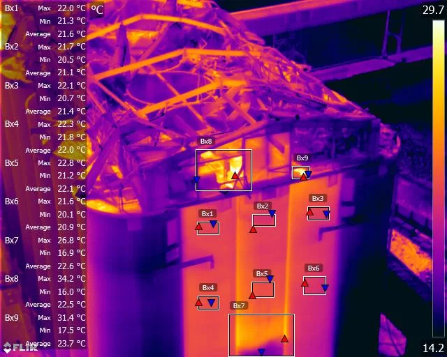
Visual imagery alongside the thermal. Structural condition, collapse, the state of a stack or silo, and the progress of clearance are all recorded from the same flight, which matters for the insurance and investigation record as much as for the response.
Reporting at the tempo the incident needs. During an active phase that can mean several flights a day with figures out immediately to the people making decisions. As the site cools it reduces to weekly and then to periodic checks, and the specification stays constant throughout so that the whole sequence remains comparable.
At a glance
What ongoing thermal monitoring provides during and after a fire, and what it does not.
- Repeat measurement of the same points, to a fixed flight pattern, so that today’s figures can be compared with last week’s rather than described.
- Flown from outside the exclusion zone, under a risk assessment written for the specific incident, alongside the emergency services and the site’s own controls.
- Supports the decisions that follow the fire: whether a mass is still burning, whether it is safe to re-enter or start clearing, and when the site can genuinely be stood down.
- Reported as calibrated temperatures with the conditions recorded, in a form that stands up with insurers, regulators and investigators afterwards.
- Sustainable over months, not just days. Cadence can start high during the active phase and reduce as the site cools.
- This is observation and reporting, not firefighting. Drone Media Imaging supports the responsible authority and does not direct or undertake any part of the fire response.
A fire that looks out and a fire that is out are different things, and only one of them can be measured.
Related Thermal Work
How It Works Around a Live Incident
Exclusion zones, bespoke risk assessment and who is in charge
Flying around an incident is not ordinary survey work, and the operational side of it matters as much as the thermography.
The survey works from outside the cordon. Where the emergency services or the site operator have imposed an exclusion zone, the aircraft operates outside it and the camera reaches in. That is one of the principal reasons for using this method at all: it produces measurements from ground nobody is permitted to stand on.
The risk assessment is written for the incident, not taken off a shelf. A burning site introduces hazards that a normal survey does not: thermal plume and turbulence over the seat, smoke affecting visibility and the sensor, unpredictable structural collapse, aircraft and helicopter activity overhead, and a control structure that changes as the response develops. Each of those is assessed for the specific site before anything flies.
Command sits with the responsible authority throughout. During an active incident the fire and rescue service is in charge of the scene, and afterwards it is the site operator or their appointed lead. Flights happen with their knowledge and agreement, on their timings, and stop when they say so. Drone Media Imaging observes, measures and reports. It does not direct the response and does not take part in firefighting.
The work can run for a very long time. Bulk material fires are measured in weeks and months rather than days, and the value of the record grows as it lengthens. A monitoring programme that starts within days of the incident and continues through clearance produces the full temperature history of the site, which is exactly the document that gets asked for afterwards.
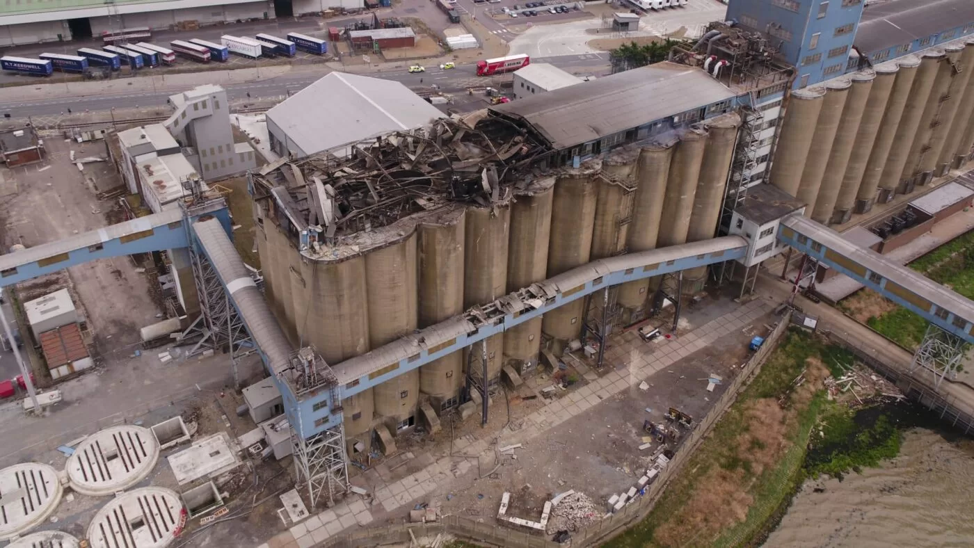
Thirteen Months of Fire Monitoring at a Port Grain Terminal
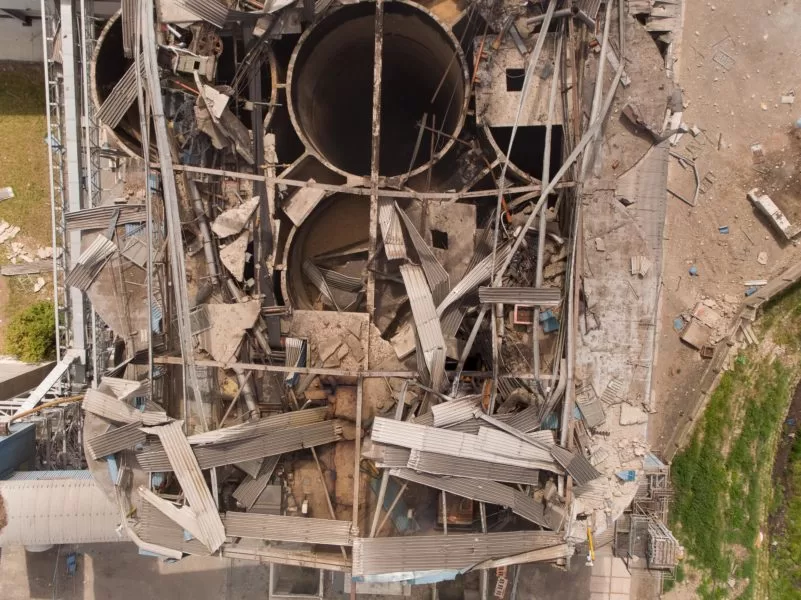
A dust explosion and fire in a port grain store. Monitoring began two days after the explosion and continued for thirteen months, at first three flights a day, seven days a week, flown from outside a fifty metre exclusion zone under a risk assessment written for the incident. Calibrated temperature data went to the crisis management team throughout, and measurable heat persisted long after demolition.
What the Camera Cannot See
On an incident this matters more than anywhere else in thermography, because a misplaced reassurance can put people back into a building that is not safe.
It measures surfaces, and a fire in a bulk mass is inside. The temperature of a silo wall, a bale stack or a heap of waste is not the temperature of the material at its centre, and there is no fixed relationship between the two. A mass can present a modest surface temperature while remaining dangerously hot inside, particularly where the outer layer has been wetted or has cooled first. A cooling surface is evidence, not proof, and the reports say so explicitly. Confirmation comes from probe temperatures, gas monitoring and, in the end, opening the mass under controlled conditions.
Smoke and steam obstruct it. Thermal cameras see through some atmospheric conditions better than visible ones, but dense smoke, steam from firefighting water and heavy plume all attenuate the signal and can put a point out of reach for that flight. That is recorded rather than worked around, and the affected areas are marked as not surveyed.
Absolute accuracy is degraded at these temperatures and distances. Very hot targets, long ranges, smoke in the path and unknown surface conditions all reduce how defensible an absolute figure is. That is precisely why the value sits in consistency rather than in a single number: the same point, measured the same way, on successive days, produces a reliable trend even where the absolute value carries a wider margin than a laboratory measurement would.
It does not establish cause. Where a fire started and why is a matter for fire investigation. The thermal record supports that work, sometimes substantially, by showing where the hottest and longest-burning material was, and it does not replace it.
What it does exceptionally well is provide repeatable, dated, measured coverage of a site that no one can safely walk on, for as long as the incident lasts, and hand the people making the difficult decisions something better than an opinion.
The reason these incidents last so long is that a fire in a deep bed of material is not the same phenomenon as a fire in a room, and it does not behave as people expect.
It burns without flame. Smouldering combustion happens at the surface of the material itself, at lower temperatures than flaming fire and with very little oxygen. It produces little visible sign, spreads slowly through a mass, and can continue for weeks. Because it needs so little air, sealing a store or damping the outside frequently does not stop it.
The material insulates its own fire. Grain, wood chip, waste and baled product are all poor conductors, which is why they are difficult to heat evenly and equally difficult to cool. Heat generated in the middle cannot escape, so the centre stays hot long after the outside has cooled, and water applied to the surface reaches nowhere near it. That thermal isolation is what makes surface measurement an indicator rather than an answer, and it is why the temperature curve flattens out and then stubbornly refuses to fall.
Disturbance is the danger point. The most common moment for a smouldering fire to become a flaming one again is when the mass is opened up, because moving it introduces oxygen to material that is already above its ignition temperature. Clearance and demolition are therefore the highest-risk phase of the whole incident, not the end of it, which is exactly the point at which thermal monitoring earns its keep by showing where the hot material is before the machine goes in.
Which is why monitoring continues past the point everybody assumes it is over. Measurable heat can persist in remaining material for a very long time after the visible incident has finished and the structure has come down.
- Thermographic observation, analysis and reporting are conducted by Steve Fisher, ITC Level III Certified Master Thermographer (Infrared Training Centre; Certification #205722059), practising in accordance with the frameworks of ISO 18436-7:2014, ASNT SNT-TC-1A and ANSI/ASNT CP-105, and BINDT CMGEN Appendix B (UK training governance).
- This is observation and reporting only. Drone Media Imaging does not direct, advise upon or take part in the fire response. Command of the scene rests at all times with the fire and rescue service or, once the incident is closed, with the site operator.
- Surface temperature is an indicator of conditions within a mass, not a measurement of them. No statement is made or implied that a fire is extinguished. Confirmation requires probe temperature, gas monitoring and controlled inspection of the material.
- Flights are conducted from outside any exclusion zone in force, under a risk assessment and method statement prepared for the specific incident, and with the agreement of the authority in control of the scene.
- Repeat surveys reproduce the flight positions, pattern and radiometric parameters fixed at the first visit, so that change between surveys is attributable to the site. Conditions, obstructions and any areas not surveyed are recorded on each flight.
- Flight operations are conducted under a Civil Aviation Authority Operational Authorisation held against the PDRA-01 standard scenario, with a General VLOS Certificate (GVC) and an A2 Certificate of Competency.
- Determination of the cause or origin of a fire is a matter for fire investigation and is not offered.
Live Incident? Call, Do Not Email
For an ongoing fire or a new incident, telephone +44 (0)7463 297164. This is an incident line for sites that are burning, smouldering or recently extinguished, not a general enquiry line, and a live incident will not wait for a form and a next-day reply. Tell us the location, what is involved, who is in control of the scene and whether an exclusion zone is in force, and we will tell you immediately what can be flown, from where, and how soon.
For a site that is already cooling, or where clearance or demolition is being planned, there is more time and the normal enquiry route is fine. The monitoring specification is worth setting up properly before the first flight, because everything measured afterwards is compared against it.



