
CAA Certified with Enhanced OSC permissions under CAA No. 2565 and fully insured to £10m+ compliant with EC 785/2004
Based in Sussex in the South East, and providing Drone Aerial Services Operations nationwide throughout the UK and Ireland

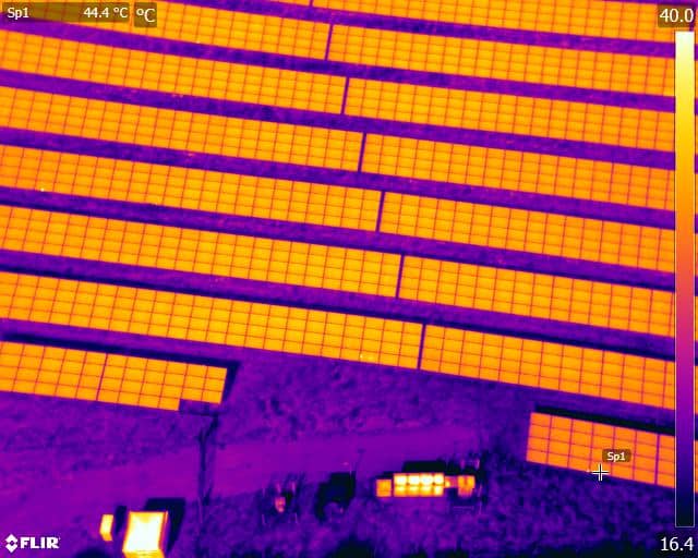
Using the latest and advanced aerial Thermal Imaging infrared inspection technology is less expensive than you might think. Using the latest Zenmuse XT Radiometric payloads for solar panel inspection, roof inspections, land surveys, infrastructure projects & agriculture management is now affordable to all and easily deployed around the UK by our category 2 certified professional thermographers at Drone Media Imaging

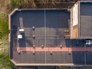
Drone aerial inspection photography is an affordable and cost effective solution for Property Inspections, Roof Inspections, Chimney and Gutter Inspections as well as real-estate Portfolios & Portraits. In addition we can photograph your business assets such as Golf Courses, Property portfolios, and other projects… Aerial Drone Photography utilising high definition cameras and DSLR equipment.

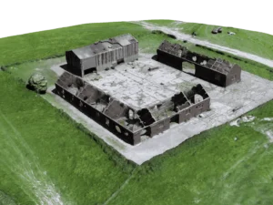
We can produce survey grade Photogrammetry 2D maps and 3D Models using sophisticated GIS equipment and software capable of providing measurements of properties, landscapes & infrastructure. These maps are sufficiently precise to give important insight into actual environmental conditions on the ground using Real-Time Kinematic (RTK) and Post-Processing Kinematic (PPK) corrections for centimetre level accuracy.

From business Corporate Videos & Events to Film & TV, Aerial Video Cinematography filming is now accessible to all production companies alike. We are happy to shoot for rushes or to create final video film throughout the UK. We are happy to assist with projects big or small, and have provide aerial video/filming for the BBC, ITV, Chanel 5 and other Independent TV & Film production companies.
Certified Master Thermographer Level 3

Free No Obligation Quotation for Drone Services


Professional Commercial Drone Services
CAA certification Operational Authorisation (OA) No.2565 | Operating Safety Case No.2565OSC | GVC & A2 CofC Qualified
Drone Media Imaging is a specialist UAV drone service provider, operating from the South East of the UK, but ready and able to deploy across the UK and Ireland.
We are licensed and certified with a CAA Operational Authorisation (OA) for sub 25kg category DAY and NIGHT flights.
With a background and reputation built over many decades in professional commercial photography, we re-trained and re-invested in our business back in 2015 so that we can now provide competitive aerial drone services across many industry sectors. We are also qualified and certified to provide thermal imaging data, not just in the air but also on the ground to cover solar panel inspections, flat roof, and structural water ingress/damage, and building insulation and thermal bridging analysis.
Drone Media Imaging’s pilots are CPL-uS qualified and liability insured. We adhere strictly to guidelines, procedures, planning practices, and risk assessment necessary to ensure the safety of staff, properties, and the general public, as well as to comply with the Civil Aviation Authority (CAA) legislation, rules and regulations.
Aerial drone photography, video and thermal imaging are not as expensive as you might think and we won’t be beaten on price for comparable service and experience!
We offer simple understandable pricing structures or can quote you specifically for your individual project requirements if you need something we have not covered. Just complete our online enquiry form which provides us with the information we need to offer you an accurate quotation.
Or just get in touch for a chat…
Recent News and Blog
What Is Photogrammetry?
How Drone Photos Turn into 2D and 3D Surveys What is Photogrammetry? "Photogrammetry" is a process for measuring actual distances through the study of photographs. In aerial Photogrammetry, aerial digital pictures taken by drones are used to gather detailed physical information from the ground. Realistic and precise photo maps and 3D reconstructions of topographic surfaces [...]

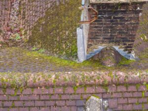
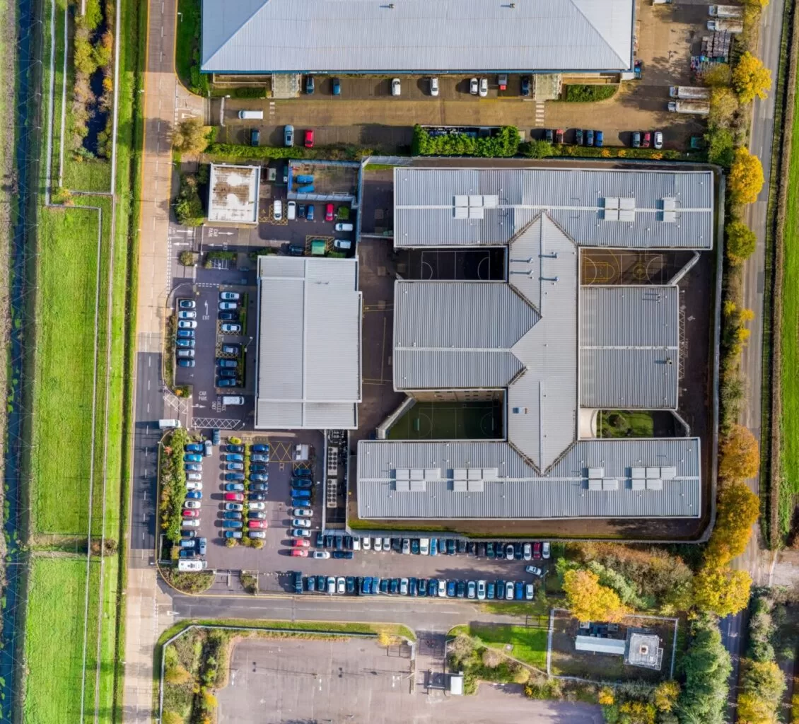
Drones & Roof Inspections
When you normally think about having a roof inspection, you likely think of ladders at least and scaffolding at worst. A human being has to climb on up to the roof with all of the health and safety considerations that this incurs, not to mention the potential for damage to the roof itself during the inspection [...]
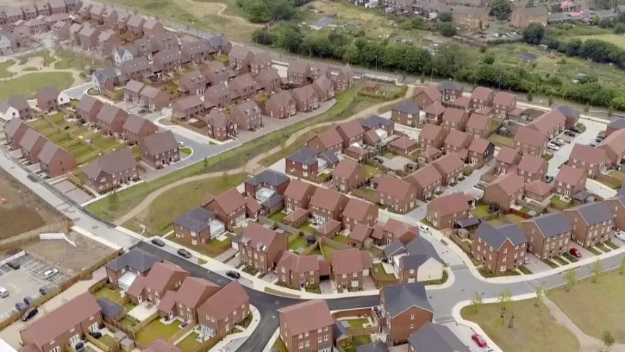
Ebbsfleet Garden City Development – BBC One Show
Ebbsfleet Garden City is an exciting housing development that's currently taking shape in Kent. We were delighted to be invited to work again with the BBC One Show to provide aerial footage of the development for a piece that they are producing. The vision for the new city is expansive incorporating both business and residential areas [...]
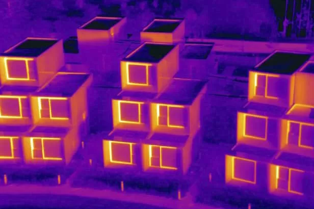
Aerial Thermography Expertise and Experience
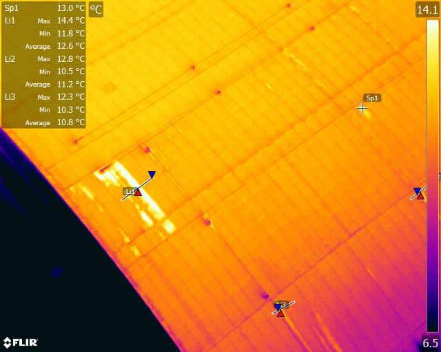
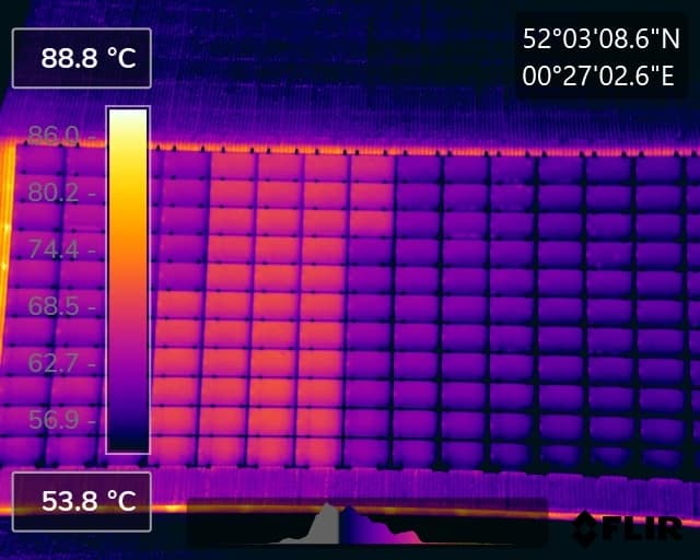
Trained and Certified in Aerial ThermographyDrone Media Imaging use trained and certified thermographers to deliver thermographic services and inspections across many domestic, industrial and commercial sectors throughout the UK. Whether it is solar photovoltaic panel inspection in accordance with IEC 62446-3:2017 and BS EN ISO 62446-1:2016 or fire detection and management in disasters zones or underground landfill fires, Drone Media Imaging can deploy across the UK quickly, efficiently and with the right experience.Aerial Thermography Category 2 Thermography certification to category level 2 focuses on radiometric temperature measurement analysis and the benefits of obtaining precise temperature data from challenging environments for diagnosing and reporting purposes. Whether for qualitative evaluation or quantitative evaluation our report and diagnosis analysis provide you with answers following a non-destructive inspection format from the air via UAV drones equipped with the latest technology. Drone Media Imaging is a small but unique drone operations company specialising in airborne thermal imaging across the UK. Our certification and experience when paired with our CAA enhanced OSC permissions, means we are more than capable of performing any aerial thermal imaging job however challenging. As level 2 thermographers we dive into the fundamental principles of surface emissivity, reflected temperature correction, spatial and measurement resolutions, and as a result providing clients with accurate data reporting that can be trusted.Aerial Thermal Imaging Infrared Cameras Thermal Imaging cameras capture the reflected radiation from a surface or heat source and convert the recorded temperatures to an image map for analysis. This unique worldview provides numerous advantageous and cost-effective non-destructive options for commercial and residential needs. Aerial thermal cameras of the highest quality provide non-contact temperature measurements in difficult to reach locations that cannot be observe from the ground. As is the case with all drone inspections, the hazards connected with operating at a height are minimised as is the potential of inflicting damage to the structure during the inspection procedure.Case Study – Explosion at a Grain Store Port of Tilbury London Following an explosion at the Port of Tilbury London grain store in July 2020, Drone Media Imaging were hired to provide aerial thermal data support to emergency service gold commanders and the senior management for the grain store. Flying thermographic data collection missions, hourly, daily, and weekly for over 13 months from the initial explosion and subsequent silo fires, we provided important thermal data reports as the fire developed, enabling the fire management strategy to be accurately measured over time. Comprehensive reports, thermal imaging, RGB photography, and video pictures were used to provide the information essential to effectively manage the problem until the building was destroyed in 2020.
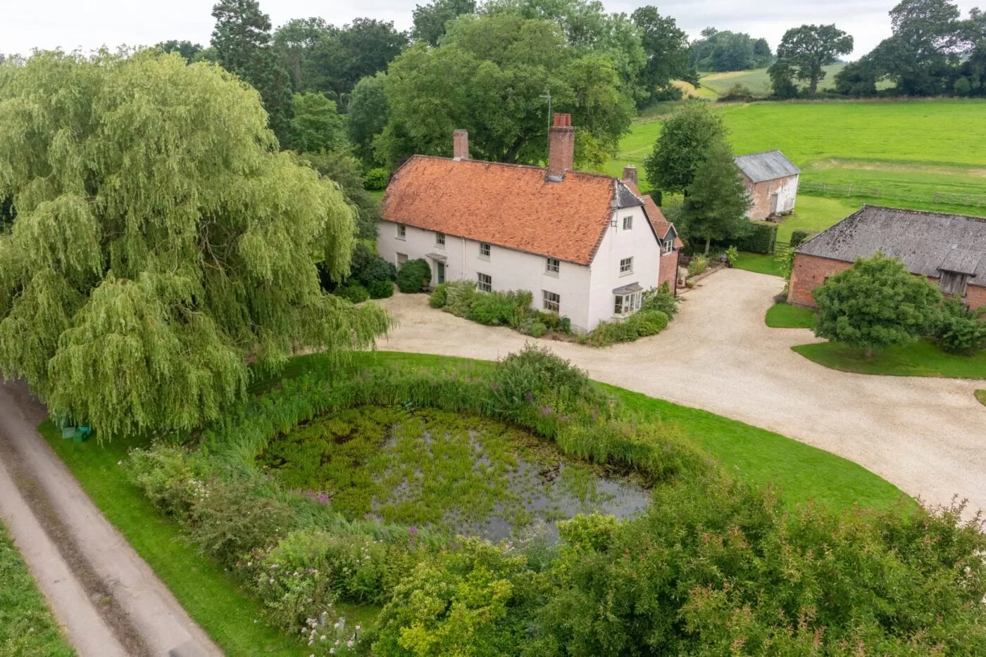
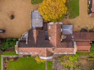
Domestic House Portraiture
House portraits make great gift ideas!It can be hard to think of the perfect gift for people sometimes, especially when you’re looking for something really special and unique to them. A house portrait can fit the bill exactly.These photos come from a client who wanted the perfect way to express her thanks to her parents for hosting her wedding at their property and I can’t think of a better way to put it than by commissioning such a special portrait of their home.Using a drone captures a property from a unique angle and is the perfect way to showcase all the beautiful home and garden features. In ‘olden days’ these portraits used to be captured via an aircraft flying at a much greater height and on a fixed flight path but a UAV or Drone can fly lower and capture much more detail as well as choose the perfect angle to show off the property at it’s very best. Not to mention that it can do all this at a fraction of the cost.Commissioning an aerial home portrait is simple to do – just get in touch with us to talk over your requirements, and provide us with the property details. We can then schedule a time to come and visit and capture your images – in this case, we did it when her parents were away so it could be a surprise.
Building Thermal Insulation Performance Inspection
Can you use a drone with a thermal camera to inspect building insulation? New buildings are now very efficient when it comes to heat management, retention and thermal living comfort, which can be attributed to architects using modern design tools, understanding and planning techniques. However, things can get missed and mistakes [...]
Enhanced Operating Permissions Granted by the CAA
Drone Media Imaging has been granted enhanced drone operating permissions from the Civil Aviation Authority (CAA) known as an ‘Operating Safty Case‘ or OSC, which puts us in an exclusive and advanced group of drone operators.
Less than 5% of drone operators currently have such permissions in the UK. Our enhanced permissions allow us to take-off, land, and fly closer to People, Properties, Vehicles and Vessels not under our control, as well as fly above 400ft to 800ft. Standard permissions now called, Operational Authorisation PDRA-01 (previously known as Permission for Commercial Operations PfCO) that the CAA grant normal drone operators are much more restrictive.
Operating under an UAS-OSC for your project is just as straight forward as for any other drone flight mission. The key difference is in the onsite procedures we deploy, safety planning implemented and research completed beforehand. The cost can vary considerably when there is a need to operate under an OSC and is very dependent upon the work required. So the first thing to do is to start a conversation with us about the project, survey/inspection, filming or photography you need to be completed and we can advise you if an OSC is needed in the first place, or whether the work can be completed under standard permissions.
Drone Filming and TV Projects We’ve Completed For Our Clients
“Providing Professional Certified and Legal Aerial UAV/Drone Photography, Video,
3D Modelling & Thermal Imaging throughout the UK and Ireland”
Aerial Photography and Video Solutions that are Affordable, Deliverable and Professional
Aerial Photography ~ Aerial Video & Cinematography ~ Aerial Survey & Inspection ~ Aerial Photometry ~ Aerial Precision Agriculture ~ Aerial Construction and Demolition ~ Aerial Time Lapse