

CAA Approved Reduced Distances (OSC) for Drone Operations
Drone Media Imaging aerial services now operating even closer!

Drones are amazing tools to complete many tasks from creative and commercial photography through building inspections and thermal surveys.
However, the legal restrictions on how far pilots can fly from a subject (whether it be person, vessel, property, or vehicle) can mean that it is not always a practical solution for every situation.
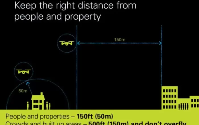
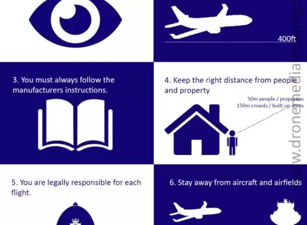
Pilots with standard permissions (PFCO) are permitted to take off and land no nearer than 30m from any person, property, vehicle, or vessel not under their control. When the drone is in flight, the separation distance increases to 50m. This means that drone flights can be a complicated solution in some built-up urban areas, necessitating extra staff for the pilot, potential road closures, and widespread communication with surrounding people and properties.
However, Drone Media Imaging is now thrilled to announce that our track record over years of safe operations and enhanced safety procedures mean that we can now operate safely at significantly reduced distances and with full permissions from the CAA. We have been working with CAA personnel over a period of months to refine and enhance our procedures to make it possible to receive our Operating Safety Case (UAS-OSC). We now have permission to take off and land from 10m and fly at a separation of 20m. This means that we are ideally placed to be able to carry out your drone work requirements where other drone operators cannot.
In addition to closer take off and flight distances, we also have enhanced permissions to fly to 800ft in altitude (standard 400ft) and 1km from the drone pilot (standard 500m). When flying near crowds of more than 1000 people, we can fly as close as 50m, when standard permissions require 150m separation distance.
So please get in touch, even if you have had a prior drone quotation which was not a practical solution for you due to distance-related issues. With our enchanted safety permissions, we are excellently placed to take care of your drone photography, videography, or thermal inspection needs.
Commercial & Domestic Drone Services
We work throughout the UK providing drone thermal imaging, photography and videography


OSC vs Standard CAA Drone Flight Permissions
 The CAA state…
“The aim of the OSC is to present sufficient evidence that all relevant hazards and resultant safety risks have been identified within an operation and that these safety risks have been reduced to a Tolerable and As Low As Reasonably Practicable (ALARP) level”
This means we have thoroughly reviewed and implemented significant safety mitigations, operational procedures and flight protocols to ensure that when we operate much closer to people, properties, vehicles and vessels, we do so in a safe professional manner.
Related Blog Posts

Photogrammetry For Roof inspections, Solar Panels, and Hard-To-Reach Assets: A Technical Approach
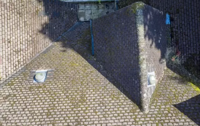
Photogrammetry for roofs, solar panels, and complex vertical structures requires far more precision than standard terrain mapping. This post from explores why traditional workflows fall short and how operators can use tools such as terrain-following, custom camera profiles, circlegrammetry, and automated vertical scanning to achieve consistent results. Packed with real-world examples and scientific validation, it provides a practical technical guide to improving model accuracy, mission repeatability, and inspection efficiency across challenging commercial environments.Capturing quality photogrammetry data from vertical and elevated structures remains one of the trickier challenges in commercial drone operations. Traditional surveying workflows fail here. Kristaps Brass, Product Owner at UgCS, has spent years working with operators who tackle these missions daily. Solar farms, building facades, communication towers, dam inspections. The pattern is consistent: manual flying burns time and money, and processed models show gaps where critical details should be. This article covers what actually works, based on field-tested methods and real operator feedback.
Understanding EASA Drone Regulations – Categories and Classes – Part 2
Understanding EASA Drone Regulations Categories and Classes – Part 2 EASA regulations have been developed to allow free circulation of drones within Europe and apply clear and comprehensive safety standards to the field of unmanned aerial systems. They become applicable in the UK on July 1st 2020. This [...]
Hospitality Industry and Drone Photography
In a world where people can shop for their next holiday from the comfort of their desktop or mobile phone, images and video are key to enticing them to visit your hospitality destination above all the others. Holidays are one of most people's biggest expenditures during the year [...]
Understanding EASA Drone Regulations – an Overview Part 1
Understanding EASA Drone Regulations An Overview - Part 1 The early part of 2019 has seen the publication of a new a set of regulations regarding drone use in Europe. Initially proposed in the Summer of 2015, the aim is to standardise UAS regulations across Europe with a [...]
Book a Drone Roof Pre-Winter Inspection and Save Yourself Money
If you live in the UK, then it won't be news to you that the weather can be a little unpredictable here - especially over the forthcoming season of winter. A year doesn't go by without there being reports of storms and the damage that they cause appearing regularly [...]

Drones and Weddings
Drones can add an exciting and different component to your wedding photography and videography and they're getting to be a much more popular part of planning to capture your big day. There's a few things to be aware of though to make sure you firstly get [...]
Drone Services Enquiry
Thermography | Inspections | Solar | Photogrammetry
Discover how drone technology can enhance your operations with a free quotation from our experts. Get a Free Quote or Make an Enquiry Today!
related posts
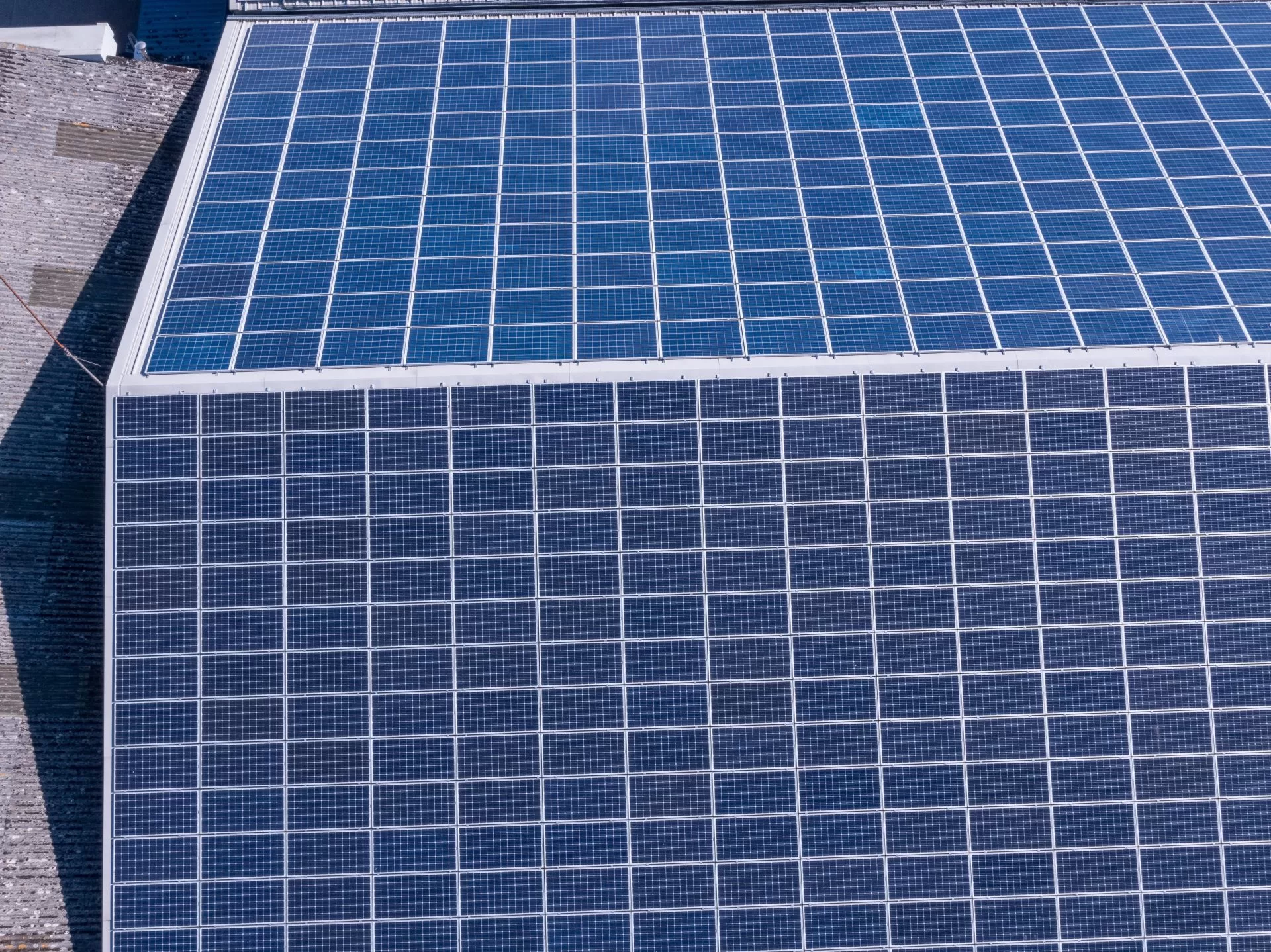
Spring and summer are peak months for solar energy production—ensure your panels are operating efficiently with a professional thermal imaging inspection. Compliance with IEC62446-3:2017 is essential for both commercial and domestic systems, helping to prevent faults, optimise performance, and maintain insurance coverage. Book your inspection today!
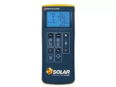
Drone Media Imaging now offers certified IEC 62446-compliant solar string testing, delivering complete electrical diagnostics for commercial PV systems. This new service verifies string integrity, insulation, voltage, current, and performance using advanced I-V curve tracing and Fill Factor analysis. Ideal for commissioning, troubleshooting, and maintenance, our testing supports safety, compliance, and ROI assurance. Combined with thermal imaging, we offer a powerful dual-inspection approach. Book today to ensure your solar array is operating safely, efficiently, and within international performance standards.
