
Marketing your Property with Aerial Drone Footage

In today’s competitive property market, buyers will move more likely to form an opinion of your property online before they decide to see it in real life.
Drone footage and photography can play a key role in presenting your property in the best possible light and attracting buyers and encouraging them to come and find out more for themselves.
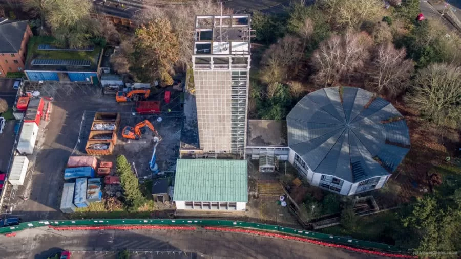
Drone footage, or an aerial perspective in general, has the ability to put your property in perspective with the environment around it in a way that ground level images cannot. For example, it can highlight how your home is nestled within rolling hills, or just a stone’s throw from the coast. The other thing that it can do is present this in a style that is pleasing to the eye, as you would in cinematography, so the viewer is immediately emotionally engaged with the property, its gardens and surroundings before they even begin to look at the details.
Whether you are using a traditional estate agent, or marketing your house yourself, your drone property video can be displayed across multiple channels such as YouTube and on other websites to get the maximum amount of exposure and a larger audience of your potential buyers. As drone operators, we will discuss with you before we fly, the areas of your property that you would like to showcase to make sure that there is not a single advantage, benefit or feature that goes unnoticed in your finished video. The idea is that your potential buyer has already fallen in love with all that your property has to offer from the outside before they even set foot inside it.
We are based in Sussex but travel nationally, so just get in touch to find out more about marketing your property with Drone Media Imaging.
Drone Services Enquiry
Thermography | Inspections | Solar | Photogrammetry
Discover how drone technology can enhance your operations with a free quotation from our experts. Get a Free Quote or Make an Enquiry Today!
related posts
Trained and Certified in Aerial Thermography
Drone Media Imaging use trained and certified thermographers to deliver thermographic services and inspections across many domestic, industrial and commercial sectors throughout the UK. Whether it is solar photovoltaic panel inspection in accordance with IEC 62446-3:2017 and BS EN ISO 62446-1:2016 or fire detection and management in disasters zones or underground landfill fires, Drone Media Imaging can deploy across the UK quickly, efficiently and with the right experience.
Aerial Thermography Category 2 Thermography certification to category level 2 focuses on radiometric temperature measurement analysis and the benefits of obtaining precise temperature data from challenging environments for diagnosing and reporting purposes. Whether for qualitative evaluation or quantitative evaluation our report and diagnosis analysis provide you with answers following a non-destructive inspection format from the air via UAV drones equipped with the latest technology. Drone Media Imaging is a small but unique drone operations company specialising in airborne thermal imaging across the UK. Our certification and experience when paired with our CAA enhanced OSC permissions, means we are more than capable of performing any aerial thermal imaging job however challenging. As level 2 thermographers we dive into the fundamental principles of surface emissivity, reflected temperature correction, spatial and measurement resolutions, and as a result providing clients with accurate data reporting that can be trusted.
Aerial Thermal Imaging Infrared Cameras Thermal Imaging cameras capture the reflected radiation from a surface or heat source and convert the recorded temperatures to an image map for analysis. This unique worldview provides numerous advantageous and cost-effective non-destructive options for commercial and residential needs. Aerial thermal cameras of the highest quality provide non-contact temperature measurements in difficult to reach locations that cannot be observe from the ground. As is the case with all drone inspections, the hazards connected with operating at a height are minimised as is the potential of inflicting damage to the structure during the inspection procedure.
Case Study – Explosion at a Grain Store Port of Tilbury London Following an explosion at the Port of Tilbury London grain store in July 2020, Drone Media Imaging were hired to provide aerial thermal data support to emergency service gold commanders and the senior management for the grain store. Flying thermographic data collection missions, hourly, daily, and weekly for over 13 months from the initial explosion and subsequent silo fires, we provided important thermal data reports as the fire developed, enabling the fire management strategy to be accurately measured over time. Comprehensive reports, thermal imaging, RGB photography, and video pictures were used to provide the information essential to effectively manage the problem until the building was destroyed in 2020.


