CAA’s 2018 Drone Awareness Study

Drones are seldom far from the front pages but quite often the stories show UAVs as something to be feared from a privacy or safety standpoint or employed by criminals for nefarious purposes.
However, the CAA launched their third annual Drone Awareness Study to try to get to the truth of the public’s perception of the increasingly common sight of drones in the sky.
With a recent report by PWC estimating the drone industry having the potential to boost UK GDP by £42bn by 2030, it’s clear that aerial filming is going to be part of all of our lives in one form or another. How it is viewed by both pilots and consumers is therefore going to be really important as the industry literally begins to spread its wings.
It would seem that everyone from pilots to the public are on the same page when it comes to one key issue – safety. Increased regulation, safety and stiffer penalties for rule-breaking were high on the wish list for the majority of people who responded.
The ‘Drone Code’ – the code launched by the CAA to promote the rules and principles for safe flight – has become increasingly recognised – a heartening fact. 93% of the public and 96% of pilots interviewed thought it was ‘vital’ that it be adhered to in order to keep the skies safer for everyone.

A good proportion also state that they would welcome stiffer penalties in terms of large fines against those who fly outside of these rules – over 400ft or within airport boundaries (with 29% feeling that breaching the latter should merit a prison sentence). Lifetime flight bans were also mooted by 19% for dangerous flights over congested areas. Safety is clearly to be a priority for all in the future if drones are to leverage both their commercial and recreational potential as predicted.
In an age where smart phones proliferate, it is unsurprising that mobile apps are perceived to be the ideal way to create and regulate responsible and legal drone use. 73% of pilots said that they planned to use an app in the future (with 45% already doing do). These apps, such as NATS DroneAssist, are felt to offer real benefits both in terms of flight planning and activity reporting. The future definitely looks to be mobile as far as drones are concerned.
It is excited for DMI to be in as early adopters in such a fast moving and potentially incredible industry. Being first has its challenges but we are proud to evolve along with it and look forward to all the new opportunities that drones will present over the coming years.

Photogrammetry For Roof inspections, Solar Panels, and Hard-To-Reach Assets: A Technical Approach
Photogrammetry for roofs, solar panels, and complex vertical structures requires far more precision than standard terrain mapping. This post from explores why traditional workflows fall short and how operators can use tools such as terrain-following, custom camera profiles, circlegrammetry, and automated vertical scanning to achieve consistent results. Packed with real-world examples and scientific validation, it provides a practical technical guide to improving model accuracy, mission repeatability, and inspection efficiency across challenging commercial environments.Capturing quality photogrammetry data from vertical and elevated structures remains one of the trickier challenges in commercial drone operations. Traditional surveying workflows fail here. Kristaps Brass, Product Owner at UgCS, has spent years working with operators who tackle these missions daily. Solar farms, building facades, communication towers, dam inspections. The pattern is consistent: manual flying burns time and money, and processed models show gaps where critical details should be. This article covers what actually works, based on field-tested methods and real operator feedback.

IEC 62446 Solar String Testing Now Available
Drone Media Imaging now offers certified IEC 62446-compliant solar string testing, delivering complete electrical diagnostics for commercial PV systems. This new service verifies string integrity, insulation, voltage, current, and performance using advanced I-V curve tracing and Fill Factor analysis. Ideal for commissioning, troubleshooting, and maintenance, our testing supports safety, compliance, and ROI assurance. Combined with thermal imaging, we offer a powerful dual-inspection approach. Book today to ensure your solar array is operating safely, efficiently, and within international performance standards.
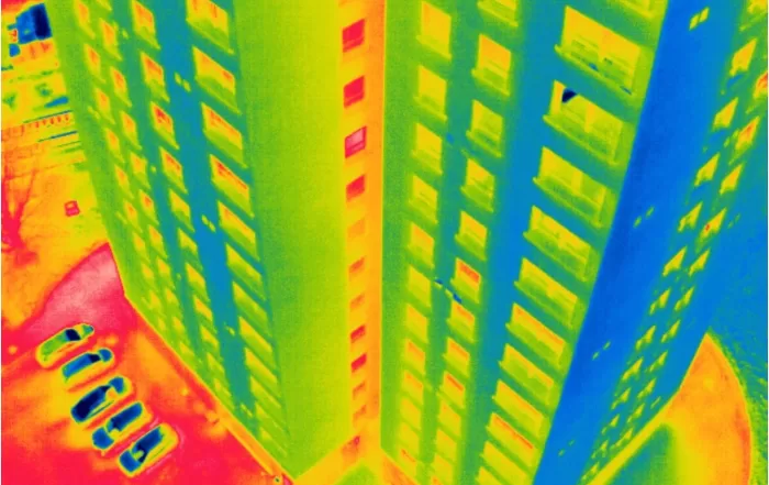
Level 3 Thermography Reporting Project – 3 Multi-Storey Residential Blocks
We supported a large thermal inspection project across three residential buildings by providing certified Level 3 thermographic reporting based on drone data collected by the client. Using a protocol we developed, they captured radiometric thermal images, which we analysed remotely to identify heat loss, glazing issues, and roof moisture indicators. This collaborative approach showcases how our clients can carry out surveys independently, while we deliver professional-grade thermographic interpretation and reporting — cost-effectively and without needing site access.
Drone Services Enquiry
Thermography | Inspections | Solar | Photogrammetry
Discover how drone technology can enhance your operations with a free quotation from our experts. Get a Free Quote or Make an Enquiry Today!