GSK Crawley Re Development
Drones and Construction Projects
Drone Video and Photography in Construction in Sussex Surrey and Kent

Getting the Bird’s Eye View

Drones offer a cost efficient way of improving a number of areas of a construction project, vastly cutting down the health and safety requirements of deploying staff to hard to access, high risk areas such as rooftops, and making regular inspection and monitoring both quick and easy.

  • Planning

  • Surveying

  • Photogrammetry Mapping

  • Analysing

  • Stakeholder Information

  • Creating Records

  • Marketing

Planning, Design and Mapping

At the planning stage, drones can provide a valuable asset in offering a quick and easy way to create a topographical map of a site.  The high level of detail means that these can be taken to architects for the basis for their designs to maximise the site space, work around any problems and take advantage of any opportunities.  Basing their designs on real world, accurate images can save time later by dealing with any problems at the design stage rather than having to make expensive adjustments during the construction process.

Maps are created with the drone flying in a pre-programmed grid to make sure that there are no errors or omissions and of course this can be done with a single pilot in a fraction of the time that it would take a team of ground based people, and also eliminate the possibility of measurement errors.

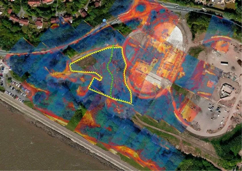
3D mapping of an area is also possible and this can be repeated at various stages during the construction to create a very visual way of assessing project progress.

Project Management

Regular drone deployment during the construction process can also provide several very important functions.  Firstly, it can inspect from a bird’s eye perspective the construction as it happens, allowing potential problems to be identified and address before the project progresses too far and repairs are expensive.   They can also be helpful when it comes to managing the project progress and areas where the budget is being met or exceeded.

These regular flights can provide both photographic and video information that can be disseminated not only to the construction personnel but also to off site stakeholders to keep them informed of the project progress. The aerial perspective can offer a far more complete picture of the site progress than a ground level view and in a fraction of the time than a site walk through.

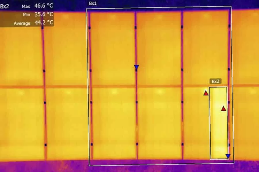
Thermal cameras can also be deployed to create a thermographic image of a site allowing efficiency to be assessed during construction.  Insulation effectiveness, areas of heat loss and even water ingress become easily visible so that targeted teams of specialists can be deployed to take an necessary corrective action.

Creating Records

There is value to having detailed and regular photographic and video footage when the project is completed.  It allows future generations to be able to see exactly what has gone on beneath the skin of a building which can be a real asset when it comes to taking care of the site for years to come.

Speak to Drone Media Imaging to leverage the power of drone flights at your next construction project.

MAKE AN ENQUIRY

Planning with Aerial Photography

Photogrammetry | Drone Mapping in Construction

As certified and qualified drone experts with are equipped and experienced to provide you with aerial photography for surveying and planning imagery for your construction project needs – Get in touch today

MAKE AN ENQUIRY

Drone Media Imaging

CAA Certified with Enhanced OSC Permissions

Blog Subject

UK Thermography Association Member Near Me?
Approved and Certified Thermographer
blog tags
MAKE AN ENQUIRY

Drone Services Enquiry

Thermography|Inspections|Solar|Photogrammetry|Filming|Photography

Discover how drone technology can enhance your operations with a free quotation from our experts. Get a Free Quote or Make an Enquiry Today!

MAKE AN ENQUIRY

related posts

  • © 2019 - Importance of Annual Solar Panel Domestic Thermal Inspections
    All, Featured||4.6 min||

    Solar panels have become increasingly popular, but many homeowners overlook the importance of regular maintenance. Annual thermal imaging inspections can detect potential issues and prevent costly repairs. Thermal imaging uses infrared technology to identify abnormal temperature patterns, indicating problems such as faulty wiring or damaged cells. These inspections offer early detection, enhanced performance, improved safety, and cost savings. Case studies and statistics demonstrate the benefits of thermal imaging inspections. By investing in regular inspections, homeowners can ensure the optimal performance and longevity of their solar panel systems.

  • © 2019 - 13 Months of Grain Store Fire Monitoring

    Thermal Fire Monitoring Following a Grain Store Terminal Explosion

    Grain Store Explosion and Year-Long Fire – July 5, 2020 – Tilbury Port, London On July 5, 2020, a series of events (possibly by a spark) triggered a large dust explosion and a subsequent fire at the Grain Store Terminal at the Port of Tilbury in London. This was a serious event that required the attention of a large-scale emergency response to get the subsequent grain fire under control and avoid additional explosions. No one was seriously hurt, which is nothing short of a miracle given the number of people on the scene and the amount of reinforced concrete and debris thrown high into the sky before raining down on the surrounding buildings.

    Traditional firefighting methods and techniques are ineffective in the case of grain storage fires. Using water to extinguish the inferno is ineffective with grain and dust fires, and the added weight might have caused a catastrophic structural collapse, exacerbating an already challenging situation. As a result, London fire teams were on the scene for days while a proper fire strategy and plan was developed and implemented, with staff always remaining on-site to monitor the situation over the following weeks.

    Throughout this early period, there was always the possibility of more explosions and the fire spreading since the grain stored in the linked silos generates dust that may ignite if the temperature is high enough. Drone Media Imaging was contracted to fly thermal imaging flights to collect temperature data to estimate fire spread and track fire management efforts over time. For instance, were the temperatures rising, falling, or remaining constant?

    We began operations on July 7, 2020, flying three flights each day, seven days a week initially, to compare temperatures and report back to crisis management teams and emergency service gold commanders. We eventually completed our thermal imaging missions one year and a month after the initial Grain Store explosion in late August 2021! While not all of the silos were full with grain, many were, and several were burning at temperatures far beyond 800°C. Before the fire could be quenched, the building had to be entirely demolished. Temperatures more than 80°C were still being recorded in the grain that remained on the ground after demolition 13 months later.

    Gaining safe access to the terminal to fly was not without difficulty, as emergency services had imposed a 50m exclusion zone surrounding the terminal due to the possibility of additional explosions. As a result, our risk assessments and method statements had to be developed specifically for this circumstance and rigorously tested to assure both safe drone flights and the most accurate thermal data gathering at this vital juncture.

    We continued to provide the Port of Tilbury London and the accompanying emergency services with daily and weekly calibrated temperature measurements that documented the progress of the grain store fire over 13 months. As thermal infrared aerial specialists, we provided data in the form of detailed reports, thermal imaging, RGB photographic and video footage.