The Process of Collecting Survey Grade Data
Photogrammetry: The Process of Collecting Survey Grade Photo Data
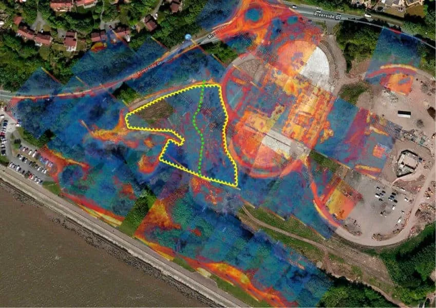
The job of aerial mapping and surveying depends on high accuracy and precision.
Using GPS correction technology precise positioning data and information for the drone can be achieved while it is deployed. Real-Time Kinematic (RTK) systems built into survey grade drone technology expand upon and increase the already existing centimetre accurate Ground Control Point techniques (GCP) and Post Processing Kinematic (PPK) techniques used by surveyors.
What is Real-Time Kinematic (RTK) and Post Processing Kinematic (PPK) ?
RTK is an application of surveying to correct for common errors in current global navigation satellite systems (GNSS). When the signal from satellites travels towards the receiver, it goes through 20,200 km of ionosphere and atmosphere down to Earth. The ionospheric effect significantly slows the signal and can disturb it on the way. In addition, many factors, such as clouds, or obstacles, can affect the travel time and increase the position error. To deal with these issues, RTK comes to the rescue.
For RTK, you need two GNSS receivers: one is static and called a “base station,” the other is moving and is called a “rover.” While both receivers observe the same satellites simultaneously, the static base station is placed at a point with known coordinates (a benchmark or a point measured beforehand). Considering the known coordinates and receiving satellite signals, the base transmits corrections to the moving rover. This way, the rover can get sub-centimetre accurate positioning.
PPK is an alternative technique to Real-Time Kinematic (RTK). With PPK workflow, accurate positioning does not happen in real time, all algorithms are applied afterwards. Both base on the ground and rover (usually on a UAV) record raw GNSS logs, which are then processed to receive an accurate positioning track back at the office.
:- Resource EMLID Technology


What are Ground Control Points ?
Ground Control Points (GCP) simply refers to an item (such as a painted cross or checkerboard) that is situated on the ground and whose coordinates are known precisely.
The ground control points, and their coordinates are then used to help drone mapping software accurately position your map in relation to the real world around it. The GCPs are spaced out evening on the ground and need to be completely visible to the drone as it takes the aerial photographs from its mission.
These pictures showing the GCP and combined with its known precise position on the ground ensure accuracy in the maps that are created.
What is the Global Positioning System (GPS)?
The Global Positioning System (GPS) is described as a network of satellites that keep track of the location of travellers, aircraft, and other positioning equipment. GPS has been around for a while. GPS technology, such as that included in a smartphone, can monitor your position continuously down to a few meters under clear line of sight, even when you’re not using it.
Originally created by the U.S. military in the 1970s, GPS devices have been made widely available to the public in a very short time span. A basic GPS receiver, like the one that most people have in their vehicles, can show you where you are on the globe. Though GPS data correction is required when a more exact position is desired, as accuracy is not 100 per cent. When working on a map or surveying a location where accuracy is essential, this is important.
When looking into drone surveys, accuracy is critical and therefore, it is necessary to use RTK and PPK techniques to correct real-time GPS data or to perform the adjustments after the data has been gathered. Without the capacity to provide precise position information, a conventional drone is simply camera in the sky and superb at filming scenery for TV/Movies or taking photographs for roof inspections, however, for industrial surveying, it’s pretty in effective. It is essential for drone activities performing accurate mapping and surveying, to stay precise, as well as on schedule, and within the budget.
Before GPS, it was up to the surveyor on the ground to provide position data accurately. Modern surveying methods date back to the early explorations of the world in quest of fresh territories and priceless treasures. While it is true that before GPS locations and distances were still determined using elements of geometry, trigonometry, regression analysis, physics, engineering, the introduction of GPS has made the process simpler, more cost effective and of course more precise.
Photogrammetry Mapping and Surveying by Drone
We are certified and approved drone pilots and work throughout the UK to provide both aerial and ground based photography, video/filming and thermography services. Fully insured and certified by the CAA with enhanced permissions for day and night time flights


Drone Services Enquiry
Thermography | Inspections | Solar | Photogrammetry
Discover how drone technology can enhance your operations with a free quotation from our experts. Get a Free Quote or Make an Enquiry Today!
related posts
Solar panel faults can cause significant issues for commercial businesses as well as domestic homeowners who are relying on solar power. Understanding the common fault types and causes of these faults can help avoid costly downtime and repairs.