Safe visual property inspections at height by drone
Drone Inspections and How UAVs Can Help

How can drones help with property inspections?

Safe visual inspections at height by drone

There is almost no end to the areas of commerce and industry where visual inspections of one kind or another play an important role.

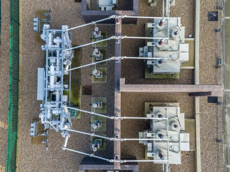
Where these inspections take place at height or in other inaccessible areas, drones can provide a practical and cost-effective alternative to using the actual eyes of the inspector. Where a UAV is deployed, the images and /or footage replace the inspector’s vision allowing them to examine and re-examine conditions from the comfort of their desk. In certain circumstances, video can be reviewed in real-time by an inspector at a remote location while the drone is in operation, but most times, detailed imagery can be captured by the pilot for later sharing and review.

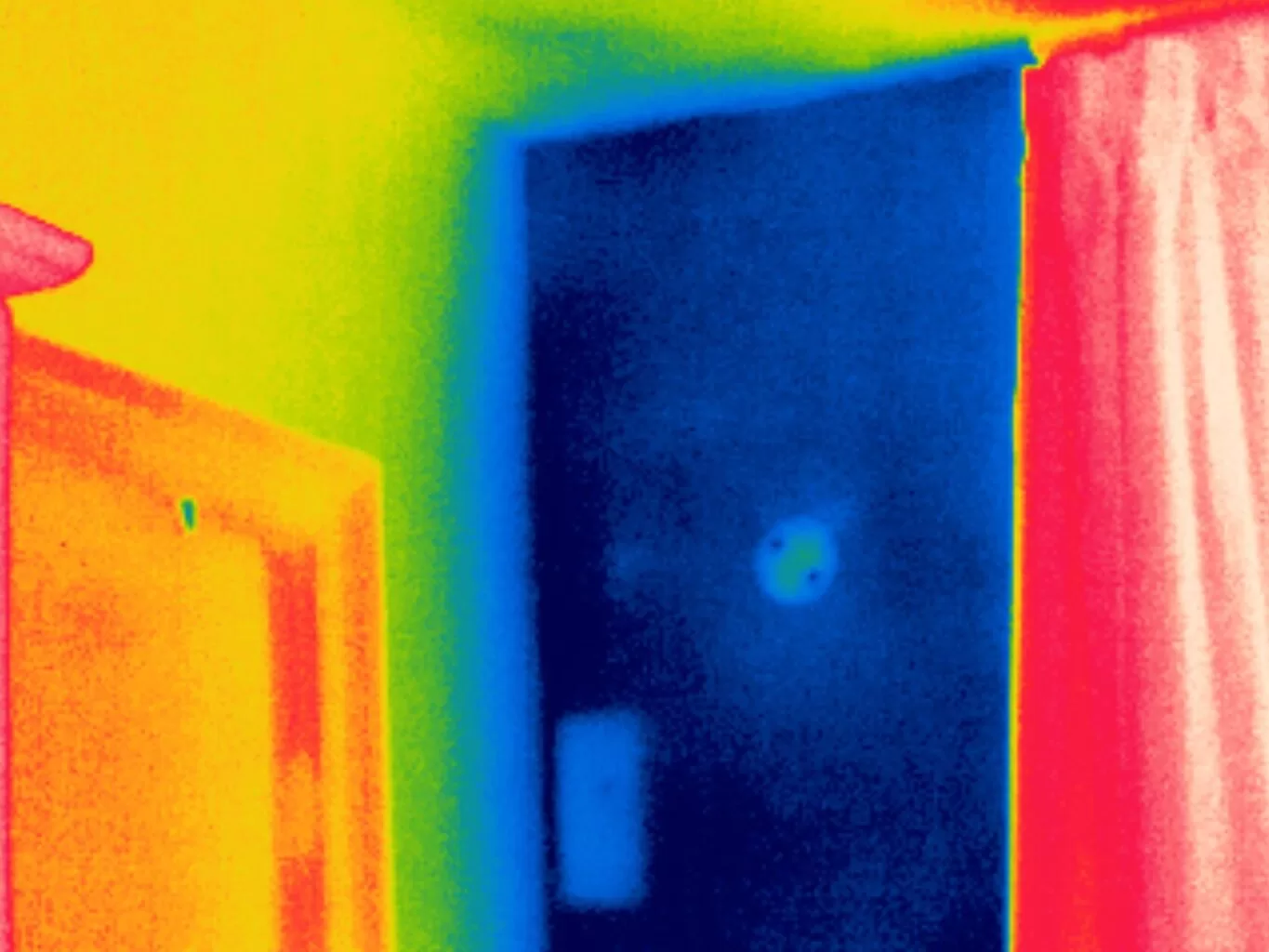
The information captured does not necessarily need to be limited to what is visible.  The addition of a thermal imaging sensor can capture information that would remain invisible to the naked eye, allowing advanced diagnostics to take place.  Assessment of insulation continuity, water ingress, thermal bridging, and heat loss are all areas where thermal imaging can provide real insight into building health in a non-destructive way and safe way.

Sending a drone piloted by certified ground-based personnel has an obvious advantage when it comes to safety. Sending inspection personnel into high or otherwise inaccessible areas can come with health and safety concerns and sometimes also with a significant price tag. Drone inspections avoid the need for this in terms of if initial assessments, ensuring personnel is only deployed if remedial action is identified, and then to the precise areas where they are needed and armed with plenty of information about what they will find when they get there.

This can mean initial and obvious savings when compared with the costs associated with scaffolding and elevated platforms and in the cost of deploying skilled repair personnel when there may not even be a fault to fix. This lower cost and ease of inspection can mean that they can be scheduled more frequently – prevention rather than cure being the ultimate goal.

Each inspection is recorded for posterity which means a detailed schedule of condition is automatically created. Records can then be retrieved and reviewed to examine progress over time.

Where Can Drone Inspections be Useful?

  • Construction – the drone is a natural fit here in terms of assessing project progress, recording infrastructure, reporting to stakeholders, and generally improving operational efficiency.

  • Chemical and Other Storage Facilities – regular and thorough inspections can prevent loss of product and damage to facilities.

  • Insurance – Fast damage assessment and detailed collection can speed up the claims process for all involved.

  • Emergency Services and Public Safety – Drones have found a growing role within the emergency services from being deployed by Search and Rescue teams to surveying ongoing fire and accident scenes providing real-time information to aid response planning and personnel deployment.

  • Utility and Infrastructure – Inspections of many types of infrastructure can mean increased responsiveness to maintenance needs.  Drones can cover large areas quickly and without involving teams of staff in potentially dangerous situations or having to cross inaccessible terrain.   Service disruption is also minimalised.

  • Agriculture – Agriculture was an early adopter of UAV technology to monitor crops and livestock, understanding irrigation issues, and creating 3D maps for detailed planning.

  • Renewable Energy – With Governments encouraging increased use of solar and wind farms, so correspondingly maintenance requirements have increased maximum productivity.  A camera in the sky, particularly when equipped with thermal capabilities is ideally placed to rapidly scan for faults.

Safe thermal inspections at height by drone
Safe thermal inspections at height by UAV

Drones can offer significant advantages over traditional inspection methods in so many areas.  Get in touch to find out how Drone Media Imaging can help you to achieve your business goals whilst reducing costs.

Safe visual roof inspections at height by drone
Safe visual chimney inspections at height by drone
Safe visual gutter and gully inspections at height by drone
GET A QUOTATION

Get your Commercial Property Photographed today!

We are certified and approved drone pilots and work throughout the UK to provide both aerial and ground-based property photography

GET A QUOTATION

Drone Media Imaging

CAA Certified with Enhanced OSC Permissions

Blog Subject

UK Thermography Association Member Near Me?
Approved and Certified Thermographer
blog tags
MAKE AN ENQUIRY

Drone Services Enquiry

Thermography|Inspections|Solar|Photogrammetry|Filming|Photography

Discover how drone technology can enhance your operations with a free quotation from our experts. Get a Free Quote or Make an Enquiry Today!

MAKE AN ENQUIRY

related posts

  • © 2019 - Domestic Solar Panel Inspections for House Roof Installations
    All, Featured||3.7 min||

    Solar panels have become an increasingly popular choice for homeowners looking to reduce their carbon footprint and save on energy costs. However, it is crucial to ensure that the installation of solar panels on house roofs is done correctly and safely. Regular inspections of domestic solar panel installations are essential to maintain their efficiency and longevity. In this article, we will explore the importance of domestic solar panel inspections, the key aspects that should be assessed during an inspection, and the benefits of conducting regular inspections.

  • © 2019 - Aerial Thermography Expertise and Experience
    All, Featured||3 min||

    Trained and Certified in Aerial Thermography

    Drone Media Imaging use trained and certified thermographers to deliver thermographic services and inspections across many domestic, industrial and commercial sectors throughout the UK. Whether it is solar photovoltaic panel inspection in accordance with IEC 62446-3:2017 and BS EN ISO 62446-1:2016 or fire detection and management in disasters zones or underground landfill fires, Drone Media Imaging can deploy across the UK quickly, efficiently and with the right experience.

    Aerial Thermography Category 2 Thermography certification to category level 2 focuses on radiometric temperature measurement analysis and the benefits of obtaining precise temperature data from challenging environments for diagnosing and reporting purposes. Whether for qualitative evaluation or quantitative evaluation our report and diagnosis analysis provide you with answers following a non-destructive inspection format from the air via UAV drones equipped with the latest technology. Drone Media Imaging is a small but unique drone operations company specialising in airborne thermal imaging across the UK. Our certification and experience when paired with our CAA enhanced OSC permissions, means we are more than capable of performing any aerial thermal imaging job however challenging. As level 2 thermographers we dive into the fundamental principles of surface emissivity, reflected temperature correction, spatial and measurement resolutions, and as a result providing clients with accurate data reporting that can be trusted.

    Aerial Thermal Imaging Infrared Cameras Thermal Imaging cameras capture the reflected radiation from a surface or heat source and convert the recorded temperatures to an image map for analysis. This unique worldview provides numerous advantageous and cost-effective non-destructive options for commercial and residential needs. Aerial thermal cameras of the highest quality provide non-contact temperature measurements in difficult to reach locations that cannot be observe from the ground. As is the case with all drone inspections, the hazards connected with operating at a height are minimised as is the potential of inflicting damage to the structure during the inspection procedure.

    Case Study – Explosion at a Grain Store Port of Tilbury London Following an explosion at the Port of Tilbury London grain store in July 2020, Drone Media Imaging were hired to provide aerial thermal data support to emergency service gold commanders and the senior management for the grain store. Flying thermographic data collection missions, hourly, daily, and weekly for over 13 months from the initial explosion and subsequent silo fires, we provided important thermal data reports as the fire developed, enabling the fire management strategy to be accurately measured over time. Comprehensive reports, thermal imaging, RGB photography, and video pictures were used to provide the information essential to effectively manage the problem until the building was destroyed in 2020.