Solar Farm Thermal Inspections
Effecient Solar Farm Maintenance Practices

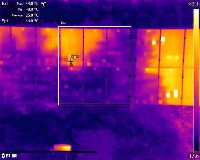
Thermal Imaging at Solar Farms
Drone Media Imaging offer solar panel inspections using state of the art thermal cameras and qualified thermographer Level 2 pilots. This means that we are almost uniquely placed amongst drone operators to guarantee data collection under the correct conditions and meaningful reports that identify any faults or anomalies. Add to this the enhanced flight operating permissions we have been granted by the CAA, puts in in a very small exclusive group in the UK.
An aerial inspection is an ideal method of assessing the condition and performance of all solar panel arrays when compared to manual ground-based inspection techniques. The advantage of an airborne camera is particularly acute when panels are in areas that are difficult to access or cover large areas, such as solar farms.
![]() Using dedicated mapping software, the drone flies a pre-programmed route or mission which allows large areas to be inspected quickly and efficiently. Any faults or anomalies that are then identified are then reported along with their exact location so maintenance teams can be deployed to exactly the right spot to carry out repairs or replacements. This means that the cost of inspections can be significantly reduced, and panels kept running at optimum levels for longer. Estimates of the reduction in inspection time are as high as 90% when using drones as compared to manual ground-based teams.
Using dedicated mapping software, the drone flies a pre-programmed route or mission which allows large areas to be inspected quickly and efficiently. Any faults or anomalies that are then identified are then reported along with their exact location so maintenance teams can be deployed to exactly the right spot to carry out repairs or replacements. This means that the cost of inspections can be significantly reduced, and panels kept running at optimum levels for longer. Estimates of the reduction in inspection time are as high as 90% when using drones as compared to manual ground-based teams.
Solar panel inspections are recommended following completion of new installations. This means that any manufacturing, PID or installation errors can be immediately identified and remedied under warranty before signing off with your installer.
Drone thermal inspections are also an important tool when negotiating the purchase of existing solar installations. An accurate map of the solar field is a valuable tool for the seller to show how well maintained and functioning the panels are. When the inspection is being carried out on the part of the purchaser, or new operator, an accurate picture of performance can be an excellent negotiation asset.
The simplicity of drone based thermographic solar farm inspections means that they can be routinely scheduled to compare year on year performance and keep on top of any faults as they develop before, they cause a loss in performance.
Contact Drone Media Imaging to discuss your requirements and maximise your solar investment.


Solar Panel Thermal Inspections
We are certified and approved drone pilots and qualified level to thermographers who work throughout the UK to provide both aerial and ground based thermography services. Fully insured and certified by the CAA with enhanced OSC permissions for day and night time flights
Drone Services Enquiry
Thermography | Inspections | Solar | Photogrammetry
Discover how drone technology can enhance your operations with a free quotation from our experts. Get a Free Quote or Make an Enquiry Today!
related posts
Trained and Certified in Aerial Thermography
Drone Media Imaging use trained and certified thermographers to deliver thermographic services and inspections across many domestic, industrial and commercial sectors throughout the UK. Whether it is solar photovoltaic panel inspection in accordance with IEC 62446-3:2017 and BS EN ISO 62446-1:2016 or fire detection and management in disasters zones or underground landfill fires, Drone Media Imaging can deploy across the UK quickly, efficiently and with the right experience.
Aerial Thermography Category 2 Thermography certification to category level 2 focuses on radiometric temperature measurement analysis and the benefits of obtaining precise temperature data from challenging environments for diagnosing and reporting purposes. Whether for qualitative evaluation or quantitative evaluation our report and diagnosis analysis provide you with answers following a non-destructive inspection format from the air via UAV drones equipped with the latest technology. Drone Media Imaging is a small but unique drone operations company specialising in airborne thermal imaging across the UK. Our certification and experience when paired with our CAA enhanced OSC permissions, means we are more than capable of performing any aerial thermal imaging job however challenging. As level 2 thermographers we dive into the fundamental principles of surface emissivity, reflected temperature correction, spatial and measurement resolutions, and as a result providing clients with accurate data reporting that can be trusted.
Aerial Thermal Imaging Infrared Cameras Thermal Imaging cameras capture the reflected radiation from a surface or heat source and convert the recorded temperatures to an image map for analysis. This unique worldview provides numerous advantageous and cost-effective non-destructive options for commercial and residential needs. Aerial thermal cameras of the highest quality provide non-contact temperature measurements in difficult to reach locations that cannot be observe from the ground. As is the case with all drone inspections, the hazards connected with operating at a height are minimised as is the potential of inflicting damage to the structure during the inspection procedure.
Case Study – Explosion at a Grain Store Port of Tilbury London Following an explosion at the Port of Tilbury London grain store in July 2020, Drone Media Imaging were hired to provide aerial thermal data support to emergency service gold commanders and the senior management for the grain store. Flying thermographic data collection missions, hourly, daily, and weekly for over 13 months from the initial explosion and subsequent silo fires, we provided important thermal data reports as the fire developed, enabling the fire management strategy to be accurately measured over time. Comprehensive reports, thermal imaging, RGB photography, and video pictures were used to provide the information essential to effectively manage the problem until the building was destroyed in 2020.